In this flight navigation app, you can access charts, weather overlays, and routing tools. Includes GPS-enabled maps, in-flight weather, traffic, and route sharing features.
AppRecs review analysis
AppRecs rating 3.2. Trustworthiness 82 out of 100. Review manipulation risk 20 out of 100. Based on a review sample analyzed.
★★★☆☆
3.2
AppRecs Rating
Ratings breakdown
5 star
51%
4 star
11%
3 star
8%
2 star
10%
1 star
21%
What to know
✓
Low review manipulation risk
20% review manipulation risk
⚠
Pricing complaints
Many low ratings mention paywalls or pricing
⚠
High negative review ratio
31% of sampled ratings are 1–2 stars
About WingX®
● VFR Free! and MilitaryFree! - only VFR flying or Active or Retired Military? Subscription is free.
● $74.95 annual subscription (or $199.95 for 3 years)
● $74.95 for Advanced IFR Subscription
● Free: 30-day Free Period
● Free: Synthetic Vision and Fuel Prices (with current subscription)
Annual Subscription
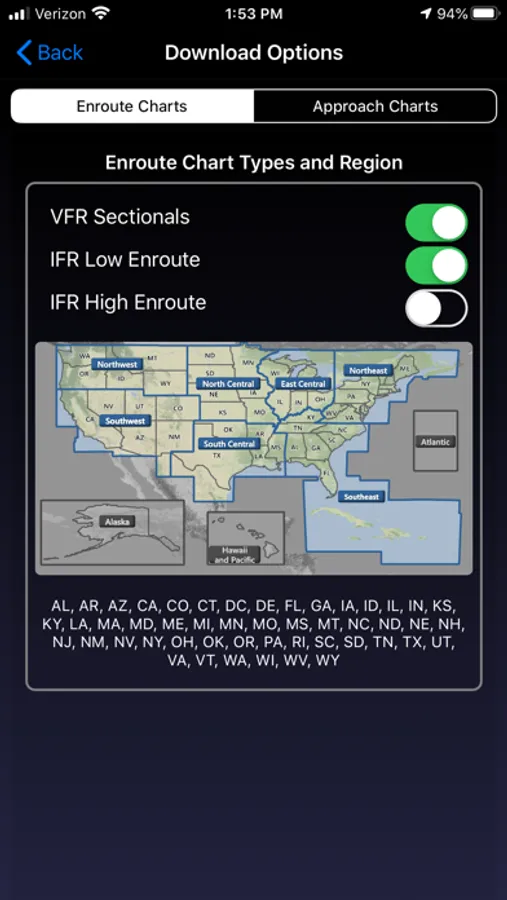
Includes VFR Sectionals, IFR Enroute Low and High, TACs, Flyway, Helicopter, Grand Canyon, and IFR Area charts plus APDs (geo-referenced), IAPs, etc
Advanced IFR Subscription
IAP geo-referencing, IAP Routing and ChartTouch
New!
Features:
● Display Instrument Approach Procedures on the Moving Map.
● Minimum Vectoring Altitude Overlays on the Moving Map.
● New Advanced Moving Map with significant performance and stability improvements
● Visual region-based moving map data download selection. Faster downloads by downloading only what you need.
● Improved weather display - better animation, faster downloading, and vastly less network bandwidth usage
● Reworked data dissemination process to enable earlier release of cycle data, improved dual-cycle data management, dynamic real-time system configuration.
● Winner of many awards including multiple Stevie Awards, Appy Awards, and Aviation Consumer.
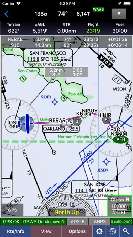
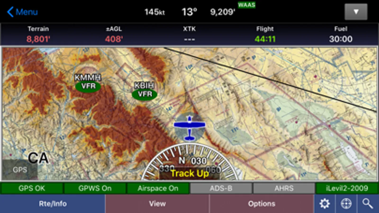
GPS-Enabled Moving Map
● VFR Sectionals, IFR Enroute Low and High, TACs, Flyways, Helicopter, Grand Canyon, and IFR Area charts
● Wx Overlays including NEXRAD composite and many other weather overlay types with animation, transparency, and low-bandwidth option (e.g. hotel rooms)
● DP, STAR, and IAP Routing (iPad only)
● North Up or Track Up
● Split Screen
● Business locations on Airport Diagrams
● ADS-B In-Flight Weather and Traffic
● X-Plane and MS Flight Sim compatible
● Ground Proximity Warning System (GPWS) - terrain and obstacles
● SmartTaxi™ - advanced taxi warning system
● FlightShare™ - share routes on the ground or in the air!
● traca™ Technology - simply draw the route
● WingX Rewind™ - record and playback flights including GPS, AHRS, and Pitot-Static.
● Auto switch to Airport Diagram
● Class B Transitions
● Search And Rescue Grids and Patterns (old/new) - Parallel, Square, Sector, and Auto Fill Grid - supports MGRS
● Overlay terrain and obstacles (terrain up to 60N)
● State Lines
● Airspace overlays
● Airspace Notifications
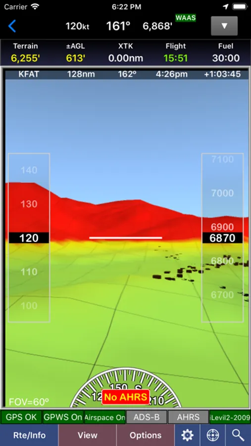
● Passive RADAR Altimeter - Terrain Elevation or AGL
● Terrain Profile View - with climb angle and 500fpm descent lines
● AHRS-driven Attitude Indicator
● Built-in Simulator
● Extra dimming for night operations
● Rubber-Banding
● User-Defined Waypoints
● Multi-Page Notepad with Undo
● Runway Extensions and Traffic Patterns
● Easy GPS Calibration - tap on moving map's altitude
● Count-Up/Down timers
● Numerous aircraft icons
● Stadium TFRs
Approach Charts
● Print charts wirelessly
● Rotate DPs and STARs
● Draw on approach charts
Wx Text
● Color-coded and decoded METARs, TAFs, winds/temps aloft
● METAR Density Altitude and Freezing Levels
Route Planning
● Victor Airways, Jetways, DPs, STARs, and even IAPs!
● Total and Longer Than Direct distances
● Flight Log shows Headings, GS, ETE, Fuel Burn using winds aloft
● Optimize Altitude for winds aloft
Flight Service
● Flight Plans and Weather Briefings with Leidos. Can be reused for fast filing
● File, Close, and Cancel flight plans
● Route and Area Weather Briefings
● Aircraft Manager for auto-fill
E6B
● TAS
● Conversions
● Distance-Speed-Time
● Pressure/Density Altitude
● Winds Aloft
● Runway Winds
● IFR Climb
● Descent Rate
Documents
● ACS and PTS
● Parts of the AIM
● AC61-65H - Including Endorsements
● AC61-67C - Stall and Spin Awarenes
● Pilot/Controller Glossary
● Aeronautical Contractions
● User-Documents
Integrated Help System
● Built-in mini-manual
Note: Continued use of GPS running in the background can dramatically decrease battery life.
Follow Us!
Twitter: @hiltonsoftware
Facebook: @hiltonsoftware
Instagram: @hilton.software
WingX® Screenshots
Tap to Rate:
Reviews for WingX®
MIflyer
Very happy with it
Been running WingX for years. Really like the split screen feature. Support has been great too.
rightgal
Support is lacking
I love the WingX program and have used it for years, but their support is less than stellar and quite opaque. There’s no option to see what your password is for the account and trying to reset my forgotten one has become a nightmare. I’m almost ready to ditch WingX and move on to something new but I’ll try for a while longer.